The Null Device
Posts matching tags 'urbanism'
2010/8/17
Foreign Policy has a photo-essay on the top 65 global cities of 2010, in its estimation; there's a short explanation here and a text-only list, with rank by population and GDP, here.
The top three cities are New York, London and Tokyo, with Paris and Hong Kong following. Other notable entries: Sydney at #9 (the only Australian city on the list; New Zealand, meanwhile, doesn't rate), Brussels is at #11, San Francisco at #12 (largely, if the caption on the photo is to be believed, for its role in the non-heterosexual world), Toronto at #14, Berlin at #16, Stockholm at #23 (perhaps largely due to Sweden's position as a pop superpower), Zürich at #24, Rome at #28 (presumably that includes Vatican City), and Copenhagen at #37. Dubai leads the Middle East at #27 (the global economic crisis hasn't kicked it off the list, it would seem), ahead of Cairo (#43) and Tel Aviv (#50). Meanwhile, the leading South American city is Buenos Aires (#22), ahead of Sao Paulo (#35), Rio de Janeiro (#49) and Bogota (54).
(Reading suggestion: scroll down the photo essay slowly, and try to guess the city before revealing the caption.)
2010/6/13
Data visualisation of the day: Locals and Tourists. Location data was harvested from geotagged photos on Flickr and plotted on maps; the points were colour-coded: blue if the poster was a local (i.e., had been in the city for more than a period of time), red if they were tourists (recent visitors with no prior history), and yellow if it was ambiguous. Here, for example, is London, with the Thames and the West End ablaze with red and the East End blue (which means that there are fewer tourists but still plenty of photographers, think Hackney art hipsters and/or kids with iPhones):
And here are Paris; tourists flock to the obvious parts (the Eiffel Tower, the Champs-Elysees, the Seine and the Île-de-Cité), whereas the locals who tend to post photos gravitate to the east, around the Bastille and such; the affluent, conservative southern arrondisements are largely a wasteland, photographically at least. In Berlin, meanwhile, tourists fill the city's broad central boulevards, the Tiergarten and Alexanderplatz and Karl-Marx-Allee, and visit the East Side Gallery, but there's a lot of local photography happening around Kreuzberg/Neukolln.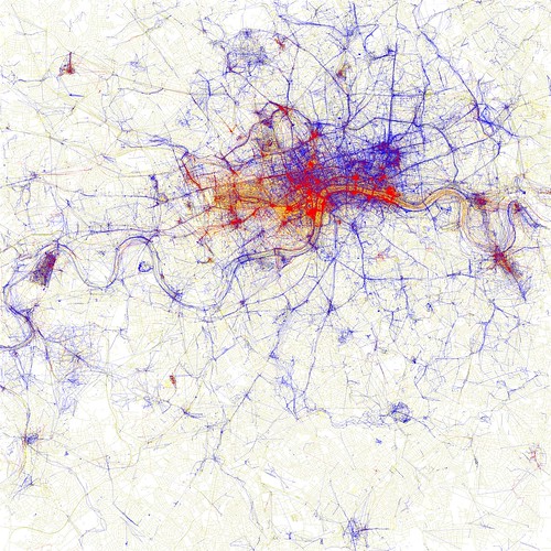
In fact, one could use the frequency of non-tourist photography for an area as a predictor of cultural vibrancy. Areas where a lot of photos are taken by people who live in the same city and not by tourists could be the kinds of broad areas where local scenes form, and the kinds of people who engage in cultural activity beyond passive consumption (sometimes referred to as "hipsters") are more likely to be found. This is borne out by other maps: Melbourne (there are specks of blue around the inner north, while the sprawling suburbs are largely empty). In New York, meanwhile, Manhattan glows with tourist activity but Brooklyn is veined with blue.
Of course, the amount of blue space on these maps is considerably larger than any nexus of cultural activity would be; it'd cover the areas where events take place, where the participants live and work, and spaces in between. However, it does make one wonder whether one could data-mine the buzz of a city by correlating Flickr photo geodata or other indices of participation with other data; possibly transport routes?