The Null Device
Posts matching tags 'geography'
2013/3/11
The latest example of the caprice of artificial borders: residents of a coastal village in Kent have found themselves facing high mobile phone bills as their phones latch onto signals from France, across the channel. Then, when their iPhones and Samsung Galaxys inevitably fetch data from the internet, they incur extortionate roaming charges, set at the dawn of time when mobile data abroad was the province of executives with deep expense accounts and left in place because bilking people for checking the email across a border is a nice little earner for the phone companies.
The bay is blocked by the white cliffs from receiving UK signals and people in the village sometimes get connected to the French network depending on atmospheric conditions and the weather. Nigel Wydymus, landlord of the Coastguard pub and restaurant next to the beach, said: "We are a little telecommunications enclave of France here.The phone company, helpfully, advised residents of and visitors to such villages to switch off mobile data roaming:
The spokesman from EE, which covers the T-Mobile and Orange networks, said: "We always recommend our customers switch off roaming while they are in this little pocket of an area to ensure that they are connecting to the correct network, because we cannot control the networks from the other side of the water."This minor absurdity is a result of the distortions of topology caused by a system whose building block is the post-Treaty of Westphalia nation-state, and which, by fiat, sets the distance between any two points within such a state to be a constant. From the mobile phone system's perspective, the distance from Dover to nearby Folkestone is exactly the same as that to London, Glasgow or Belfast, all of which are orders of magnitude nearer than Calais across the Channel. The costs of carrying the data across a system of base stations and trunk cables is part of the settlement of maintaining the legal fiction of the unitary nation-state; the sharp shock of roaming charges is the other side of the coin, a licence for the carriers to make a bit back from the tourists and business travellers, who are either in no position to complain or are used to the data they consume on the go being an expensive premium service. After all, it costs a lot to live in The Future.
Kent isn't the only place where travellers may find themselves virtually (though potentially expensively) abroad; a while ago, I was walking in Cumbria, near Ravenglass, and found myself on the Isle of Man (a separate jurisdiction with its own phone companies and, lucratively, roaming rates).
I wonder how this situation is handled on the continent, where the phones of people living near borders are likely to inadvertently cross them on numerous occasions. Do, say, Dutch phone companies charge roaming Belgians local rates? Do Italians find themselves inadvertently roaming in Switzerland or Croatia? Or do base stations on either side of a border do double-duty, serving both countries' carriers as if they were local?
2012/3/24
One of the dividends of the melting of Arctic ice is on its way; this summer, three flotillas of icebreakers and cable-laying ships will begin laying submarine cables crossing the Arctic, from London to Tokyo. The cables, which will go through Canada's Arctic Archipelago and skirt the Russian north coast, will cost between $600m and $1.5 billion each and will reduce the latency between London and Tokyo (a link which now goes either through the Indian Ocean or the long way around, through North America) by 30%, shaving 60 milliseconds off; which translates to up to $25 million per millisecond saved.
As important as network links are in today's hyperconnected world, the fact that some three or so billion dollars (a sum which could buy a lot of other things, from providing millions of people with clean water to patching up bridges and power plants) was easily found for a 60-millisecond speed increase is mostly to do with being massively useful for high-frequency algorithmic trading. Objectively, it makes no difference whether a transaction between London and Tokyo takes 170 or 230 milliseconds to take place—though whether the transaction gets in before or after the rest of the market is the difference between profit and loss. Already, a significant part of the global financial system resembles a game of Core Wars played with real money; large amounts of wealth are conjured into being in finance houses by wartrading bots created from GPUs and FPGAs by extremely well-renumerated geeks, and many of the brightest minds of our age are eschewing the vows of poverty which go with the academic life or the modest salaries promised by pure science and medical research and instead going into creating the bots that will outcompete the current generation of bots. As such, there's all the money in the world for faster network links between global financial centres, and the Arctic link should tide the traders of London and Tokyo over until someone opens a finance house on Novaya Zemlya or in the Canadian arctic and beats both sides to the punch. After all, 299,792,458 metres per second is not just a good idea; it is about as iron-clad a law as there is.
The article suggests that, while algorithmic trading will benefit from the link, it will also be open to general traffic. Though, since the reduced latency is a competitive advantage worth countless millions, I wonder whether civilian access to the cable will be specially configured to slow packets down by a few milliseconds.
2011/5/26
A few London transport map links: here there is a detailed, zoomable map of the London Underground and surface railways, showing the locations of stations (both operational and closed) and tracks.
Meanwhile, the Green Party's candidate for Mayor of London has an interactive map showing how far London's bicycle hire system would reach if it were the size of Paris's; which is to say, quite a bit further, particularly to the north and south. Perhaps it'd even be possible to live near a Boris Bike station without being made of money.
2011/1/6
An article looks at the question of why the poorer parts of cities in the northern hemisphere tend to be in the east:
The reason for this is that in much of the northern hemisphere, the prevailing winds are westerlies – blowing from west to east. The massive, unchecked pollution from these early industries would therefore drift eastward, making the air quality much lower in the east end of cities, lowering the desirability (and price) of the housing. Middle classes preferred the cleaner west ends.
In many cities, this will have been compounded – or confused – by the direction of the main river in the environment, which would have been relied on for many uses, including sewerage. London, as an example, displays a massive east/west divide, caused in large part by both early industry and the west-to-east flow of the River Thames.Of course, as polluting industries are moved out of affluent countries to eastern Europe, China and the developing world, the old industrial areas, positioned close to the centres of cities as they were before widespread car ownership, are being cleaned up and gentrified, and the rich/poor divide is turning into a boring-rich/exciting-rich divide.
In Australia (well, at least in Melbourne and Sydney), the relationship is reversed, with the western suburbs being poorer and more industrial, and the eastern suburbs being more affluent. One would imagine that this would suggest that the prevailing winds in Australia are easterlies, but the wind map linked seems to contradict this; if anything, Melbourne seems in the path of westerlies, and northeasterlies don't start until somewhere around the Tropic of Capricorn.
(via Boing Boing) ¶ 2
2010/12/16
Data visualisation of the day: if you draw lines between the locations of people connected to each other on Facebook, you get this map of connections:
A few interesting observations:
- There are notable dark patches: China is an obvious one, between the Great Firewall and the prevalence of home-grown websites. Brazil is also dark (presumably because everyone's on Orkut instead), as is Russia (LiveJournal is apparently the big thing there to this day). The Middle East is also largely Facebookless, with the exception of Turkey, Lebanon and Israel. Africa is also largely dark, with a few, largely self-contained patches of light.
- The east coast of Australia is more strongly connected to New Zealand than to the west coast.
2010/11/14
Google's Open Source blog has a video interview with Australian open-source developer Rusty Russell, who has contributed to gcc and the Linux kernel, in which he puts forward a possible explanation for why there are disproportionately many Australian open source developers; and explanation based upon that ubiquitous factor within Australian culture and society, the tyranny of distance. Russell contends that the fact that Australia is so far away from the centres of technological development means that young Australians with a talent for coding are more likely to express that by getting involved in projects on the internet, and, more often than not, open-source projects.
I wonder whether this means that areas with high concentrations of technological companies and startups (such as the Bay Area, London and Berlin) contribute less to open source than (internet-connected) places in the middle of nowhere.
2010/8/17
Foreign Policy has a photo-essay on the top 65 global cities of 2010, in its estimation; there's a short explanation here and a text-only list, with rank by population and GDP, here.
The top three cities are New York, London and Tokyo, with Paris and Hong Kong following. Other notable entries: Sydney at #9 (the only Australian city on the list; New Zealand, meanwhile, doesn't rate), Brussels is at #11, San Francisco at #12 (largely, if the caption on the photo is to be believed, for its role in the non-heterosexual world), Toronto at #14, Berlin at #16, Stockholm at #23 (perhaps largely due to Sweden's position as a pop superpower), Zürich at #24, Rome at #28 (presumably that includes Vatican City), and Copenhagen at #37. Dubai leads the Middle East at #27 (the global economic crisis hasn't kicked it off the list, it would seem), ahead of Cairo (#43) and Tel Aviv (#50). Meanwhile, the leading South American city is Buenos Aires (#22), ahead of Sao Paulo (#35), Rio de Janeiro (#49) and Bogota (54).
(Reading suggestion: scroll down the photo essay slowly, and try to guess the city before revealing the caption.)
2010/5/2
The Economist rationalises the "outdated and illogical" map of Europe:
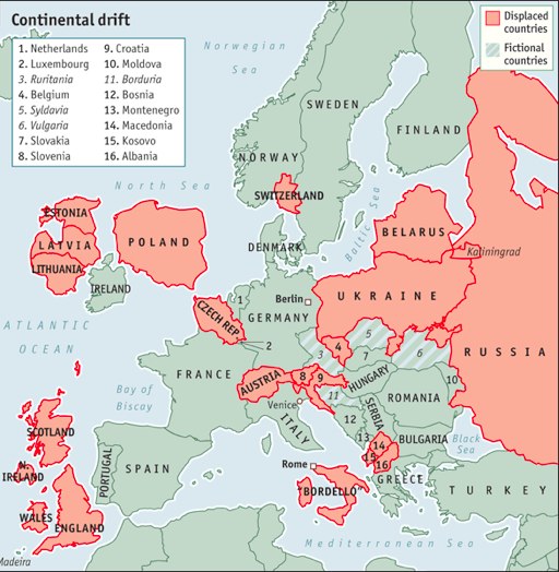
Belgium’s incomprehensible Flemish-French language squabbles (which have just brought down a government) are redolent of central Europe at its worst, especially the nonsenses Slovakia thinks up for its Hungarian-speaking ethnic minority. So Belgium should swap places with the Czech Republic. The stolid, well-organised Czechs would get on splendidly with their new Dutch neighbours, and vice versa.
Germany can stay where it is, as can France. But Austria could shift westwards into Switzerland’s place, making room for Slovenia and Croatia to move north-west too.* They could join northern Italy in a new regional alliance (ideally it would run by a Doge, from Venice). The rest of Italy, from Rome downwards, would separate and join with Sicily to form a new country, officially called the Kingdom of Two Sicilies (but nicknamed Bordello). It could form a currency union with Greece, but nobody else.
2010/5/1
Some recent random posts related to urbanism, urban planning, architecture, transport, infrastructure and such:
- The World's Strangest Housing Communities. Includes Chinese replicas of American suburbia, sadly derelict futuristic pod cities in Taiwan (alas, now destroyed), and rumours of midget villages in rural America. Not to mention Alphaville, the chain of high-security gated cities in which Brazil's professional élites live behind electrified fences, guarded by a private army and entering and leaving only by helicopter (and which inspired a Jean-Luc Godard film of the same name),
- A Berlin-based street artist calling themself EVOL uses photographic prints to convert utility boxes and planters into miniature replicas of decaying tower blocks:


- A piece on hand-drawn maps, and the situations in which they are particularly useful, when subjective psychogeographic experience is more important than objective accuracy.
- A piece in The Economist about Portland, Oregon, a city which "looks to Amsterdam, Helsinki and Stockholm for ideas" and is touted by some as a model for a more sustainable America (though also mocked for being the cultural epicentre for hipsters and White People.
- Another possible alternative for living: Inhabited balloon cities perched atop high-altitude wind systems.
2008/8/29
Britain's most senior cartographer has railed against electronic maps, arguing that they obliterate the rich geography of Britain, reducing an ancient landscape filled with history to a set of roads:
Churches, cathedrals, stately homes, battlefields, ancient woodlands, rivers, eccentric landmarks and many more features which make up the tapestry of the British landscape are not being represented in online maps, which focus on merely providing driving directions, said Mary Spence, President of the British Cartographical Society.
"Corporate cartographers are demolishing thousands of years of history, not to mention Britain's geography, at a stroke, by not including them on maps," she said. "We're in danger of losing what makes maps unique; giving us a feel for a place."While Spence's complaint seems superficially plausible, it misses the forest for the trees (no pun intended), focussing on the specifics of the implementations of a yet novel technology and ignoring the momentum that is driving progress forward. It's true that, when you look at a map in Google Maps or on a satnav unit, it, by default, shows you a minimalistic, functional map, consisting of sparse lines rendered in brightly coloured pixels. However, it is also true that there is more than that beneath the surface. Google Earth, Google Maps' big brother, renders the globe with a panoply of user-selectable layers, from the standard geographical landmarks (roads, railways, cities) to links to geotagged Wikipedia pages and photographs (albeit on some weird service nobody uses because everyone's on rival Yahoo!'s Flickr). Google Earth itself allows users to draw their own layers and send links to them. And OpenStreetMap takes it one step further, doing for mapping what Wikipedia did for textual reference works; if you find that your map of Gloucestershire is missing Tewkesbury Abbey or your map of Cental Asia got the Aral Sea wrong, you can correct it. And if you live somewhere where there is no Google Maps (and, indeed, no Ordnance Survey), you can map it yourself (or get some friends together to map it; or petition the local government/chamber of commerce to buy a few GPS units and pay some people to drive around with them, assembling a map). This has resulted in excellent maps of places Google hasn't reached yet, like, say, Reykjavík, Buenos Aires and much of Africa.
Making maps is only half of the equation; it's when one considers what can be done with all the mapping data that things become really exciting. Now that mobile data terminals (which people often still refer to as "phones"), with wireless internet connections and GPS receivers, are becoming commonplace, these soulless, history-levelling map databases are transformed into a living dialogue with and about one's surroundings. Already mobile phones which can help you find various amenities and businesses near where you are are being advertised. It is trivial to imagine this extended from merely telling you where the nearest public toilet is or how to get home from where you are into less mundane matters. Press one button, it points out historical facts about your location, with links to Wikipedia pages; press another one, and it scours online listings and tells you what's happening nearby. Follow any link to flesh out the picture as deeply as you have time for.
Spence's argument reminds me of a lot of the beliefs about computers from the 1950s, when computers were expensive, hulking beasts which were programmed laboriously using punched cards and rudimentary languages like FORTRAN and COBOL. It was too easy to extrapolate the status quo, the baby steps of a new technology, in a straight line and see a future of centralised hegemony and soul-crushing tedium, where the world is reorganised around the needs of these primitive, inflexible machines. Of course, that world never came about, as the machines evolved rapidly; instead of being marshalled into centrally computerised routines, we got iPods, blogs and Nintendo Wiis. To suggest that computerised maps will reduce our shared psychogeography to a collection of colour-coded roads is similarly absurd.
2008/2/21
Looking out from a London-bound train from Brighton today, I noticed a peculiar sight to the west of the railway line. At one point, in the area between two railway lines, there is a lot containing a large number of old red telephone boxes, in varying states of rust and decay.
Examining the line in Google Maps, the location appears to be here, just south of the M25, and in the vicinity of Redhill and Merstham.
2008/2/6
Following up from that piece on musical tastes in the UK, there's an article in the Graun speculating on how geography and history affect musical taste:
However, some music seems entrenched in certain areas, and while some believe this is due to the mystical forces exerted by ley lines, it is more likely attributable to a single act spawning an entire movement. "I think music is more determined by musical scenes that help create a distinctive sound," says academic and journalist Simon Frith, founder member of the International Association for the Study of Popular Music and chair of the Mercury music prize judging panel. "Glasgow has that history of guitar pop, and if you listen now to [Glasgow band] Glasvegas, it could be guitar pop of any age." Frith suggests that bands are inspired by the music that immediately precedes them - the music played perhaps by older siblings - and by the music that surrounds them, in local venues, on jukeboxes, radio stations. "The jangly guitars you hear in new Glasgow bands are the same jangly guitars you will hear played in Glasgow pubs," he says.
"I've looked at the fact that industrial Yorkshire and Lancashire are particularly strong areas for community-based music, such as brass bands, handbell ringing teams and choirs," he says. "They were all very powerful, particularly in smaller communities - it's partly to do with civic rivalries." Religion also played a big part, especially Methodism in Yorkshire. "Though John Wesley believed in the simplest form of music so as not to complicate the religious message, many of the local congregations took very enthusiastically to religious music, and so grew the choral tradition,"
In more recent times, Sheffield has shown itself to be home to music with a strong storytelling sense, with acts such as Pulp, the Arctic Monkeys and Richard Hawley. "The narrative thing I find interesting," says Frith, "because I always associated Sheffield with electronic music. It was the home of Warp and the Human League - though their songs did have a sense of narrative." Russell notes the strong love of amateur operatics in the area in the late 19th and early 20th century, "which created a love of humorous lyrics". Then, of course, came the music hall tradition. "And in some way the music hall spawned the very literate songwriting with wit and humour." It is precisely this we can see in the lyrics of Jarvis Cocker and Alex Turner.
But the Scottish love of American country and western is little more than a reclamation; country and western music was largely born of the music of the Appalachian Mountains, which itself was rooted in the music brought to American shores by immigrants from Europe, especially the British Isles. So country and western has much in common with traditional British folk music, Celtic music, and Scottish and Irish fiddle styles in particular. And those old habits die hard. "Apparently, karaoke caught on much quicker in Scotland and Ireland where they had the tradition of collective singing," adds Frith, "and where they had more of a tradition of the ballad."
A survey of music sales from HMV outlets has revealed variations in mainstream musical tastes across the UK.
According to this survey, music tempo increases the further north one gets, with the west country (birthplace of trip-hop) still chilling to downbeat ambience, while Scotland gets down to 190bpm happy hardcore, which The Times reports as "a musical experience more akin to being trapped inside a tumble-dryer with a power drill". Meanwhile, Northern Ireland is big on country music, Birmingham has kept its historical associations with heavy metal, the mainstream in London and the south-east is R&B (I wonder whether this includes grime and dubstep), Manchester is a stronghold of "indie" (by which presumably means of the NME/Carling/Xfm variety, given that this is a HMV sales survey), in Yorkshire they're into "goth", and in Leeds they don't like trendy NME bands.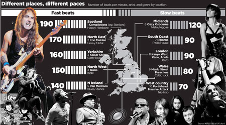
2008/1/27
As the receding polar ice caps expose land and shipping lanes, setting the scene for the next great international land grab, Iceland's University of Akureyri is offering a course in Polar Law, to prepare a generation of lawyers uniquely equipped to deal with the resulting issues:
Emphasis is placed upon relevant areas of public international law, such as environmental law, the law of the sea, questions of sovereignty and boundary disputes on land and sea, natural resources law, the rights of indigenous peoples in the north, self-government and good governance, and land and resources claims in the polar regions.
(via Boing Boing) ¶ 0
2008/1/25
With it being Australia Day, The Age has a raft of articles looking at Australian culture and identity, including one examining the idea of something being "un-Australian" (for the first time since the end of the Howard era):
Current generations might believe that to be un-Australian and its attendant "ism" were coined in the conservative 1990s, when the values debate raged and the then prime minister, John Howard, spearheaded a failed attempt to get the term mateship enshrined in the constitution. But its ancestry goes back much further. Etymologically, it began life as a literal recognition of things that were not Australian in character; the first recorded use, in 1855, described a part of the landscape similar to Britain.
Cultural commentator Hugh Mackay has argued that anything labelled un-Australian is, in fact, Australian: "Surely it's 'Australian' to do whatever Australians do. It's Australian to drink and drive, to get hopelessly into debt, lie to secure an advantage — whether political, commercial or personal — and engage in merciless and slanderous gossip. It's Australian to give vent to our xenophobia through outbreaks of racism, to reserve our nastiest prejudices for indigenous people, and to worship celebrity … It's Australian to do such things because it's human to do them."And there's also a piece titled "I speak Aboriginal every day", about the surfeit of Aboriginal place names in Australia, most of their meanings all but forgotten to most of the people who use them:
Prahran turns out to be an Aboriginal word — a corruption of Birrarung (mist, or land surrounded by water). Dandenong was Tathenong (big mountain). Geelong comes from Tjalang (tongue). Moorabbin means "mother's milk". Looking up a single page in a street directory now to check a spelling (because I know these words better spoken than written), I find Kanooka, Kanowindra, Kanowna, Kantara, Kantiki, Kanu, Kanuka, Kanumbra, Kanyana … and on and on. Forty-five per cent of Victorian place names are Aboriginal.I didn't know that Prahran was an Aboriginal word; if pressed, I would have guessed that it was taken from India, perhaps in honour of some earlier triumph of the British Empire (by analogy to the area near Flemington which is sometimes referred to as Travancore), or alternately came, badly mangled, from some indigenous British minority language.
2008/1/15
Paul Torrens, of Arizona State University, has developed a computer model of crowd behaviour in cities, complete with graphics. The possibilities, as is pointed out here, are endless:
Such as the following: 1) simulate how a crowd flees from a burning car toward a single evacuation point; 2) test out how a pathogen might be transmitted through a mobile pedestrian over a short period of time; 3) see how the existing urban grid facilitate or does not facilitate mass evacuation prior to a hurricane landfall or in the event of dirty bomb detonation; 4) design a mall which can compel customers to shop to the point of bankruptcy, to walk obliviously for miles and miles and miles, endlessly to the point of physical exhaustion and even death; 5) identify, if possible, the tell-tale signs of a peaceful crowd about to metamorphosize into a hellish mob; 6) determine how various urban typologies, such as plazas, parks, major arterial streets and banlieues, can be reconfigured in situ into a neutralizing force when crowds do become riotous; and 7) conversely, figure out how one could, through spatial manipulation, inflame a crowd, even a very small one, to set in motion a series of events that culminates into a full scale Revolution or just your average everyday Southeast Asian coup d'état -- regime change through landscape architecture.
Or you quadruple the population of Chicago. How about 200 million? And into its historic Emerald Necklace system of parks, you drop an al-Qaeda sleeper cell, a pedophile, an Ebola patient, an illegal migrant worker, a swarm of zombies, and Paris Hilton. Then grab a cold one, sit back and watch the landscape descend into chaos. It'll be better than any megablockbuster movie you'll see this summer.And here are emotional maps of various urban areas, including parts of London and San Francisco, created by having volunteers walk around them with GPS units and galvanic skin response meters.
(via schneier, mind hacks) ¶ 0
2007/12/21
At the stroke of midnight last night, nine new countries joined the Schengen Zone, the area in Europe without any internal borders. The zone now extends well into eastern Europe, encompassing the former Eastern bloc nations and ex-Soviet Baltic states which joined the EU in 2004, and going right up to borders with Russia and the Ukraine.
The other side of this has been a fortification of the Schengen zone's new easternmost frontier, with intensive patrols and high-tech sensors being deployed to prevent illegal immigration from (or through) their eastern neighbours.
2007/5/21
The former Communist state of East Germany, which disappeared from Europe in 1990, still exists in the Caribbean; well, sort of. There is an unpopulated island off the coast of Cuba which Fidel Castro gave to East Germany in 1972, naming it "Cayo Ernesto Thaelmann", after a Communist politician executed by the Nazis. During the Communist era, it was apparently effectively East German territory; a Party-approved pop singer made a record there in 1975. It's not known how much the DDR used the island other than that, though by the time the Berlin Wall came down, it was apparently uninhabited, to the point where those negotiating the reunification treaty forgot it existed. This state of affairs continued until 2001, when a German newspaper discovered it and attempted to sell it, upon which, the Cubans, not wanting any more capitalist running-dog lackeys in their neighbourhood, swiftly declared that the transfer was "symbolic" only.
2007/5/17
The Grauniad has a photographic piece on the first railway crossing between North and South Korea in 57 years:
The last time a train attempted to cross was on New Year's Eve in 1950, when the line was used by thousands of refugees fleeing an advance by Chinese and North Korean troops. Their journey came to an abrupt halt when US soldiers riddled the steam water tank with bullet holes. The tracks were destroyed to slow the progress of the communist forces.
Today's test run is seen as a step towards closer economic ties between rich, open South Korea and the poor, isolated North. It is hoped that the lines will eventually link to the Trans-Siberian railway and allow connections spanning more than 5,000 miles from London to Seoul.
2007/4/19
The Russians are once again talking about building a tunnel under the Bering Strait from Russia to Alaska. Apparently the US and Canada are on board, and the project is expected $65 billion, with the tunnel itself costing $10 to $12 billion; much of the rest will be spent on providing a rail link across inhospitable terrain to the heretofore unconnected northeastern frontier of Russia.
A 6,000-kilometer (3,700-mile) transport corridor from Siberia into the U.S. will feed into the tunnel, which at 64 miles will be more than twice as long as the underwater section of the Channel Tunnel between the U.K. and France, according to the plan. The tunnel would run in three sections to link the two islands in the Bering Strait between Russia and the U.S.
The planned undersea tunnel would contain a high-speed railway, highway and pipelines, as well as power and fiber-optic cables, according to TKM-World Link. Investors in the so-called public-private partnership include OAO Russian Railways, national utility OAO Unified Energy System and pipeline operator OAO Transneft, according to a press release which was handed out at the media briefing and bore the companies' logos.
Russian Railways is working on the rail route from Pravaya Lena, south of Yakutsk in the Sakha republic, to Uelen on the Bering Strait, a 3,500 kilometer stretch. The link could carry commodities from eastern Siberia and Sakha to North American export markets, said Artur Alexeyev, Sakha's vice president.I hope they run passenger trains through the tunnel when it's built. Being able to travel by train from, say, London to New York, taking the long way around, would be interesting.
2007/4/13
The Spanish and Moroccan governments are talking about building a high-speed rail tunnel under the Strait of Gibraltar, linking Europe and Africa. If it happens (and that is a big if; the entire endeavour would cost about US$13 billion and cost 20 years to construct), it would make it possible to travel from one continent to another by rail.
How far down through Africa railways could extend is another matter; I imagine a London-Johannesburg rail link would be pushing it.
2007/4/3
For years, map historians have been puzzled by the so-called "London Underground Map", and have speculated on what it could possibly represent. Now a new theory claims that, when rotated and adjusted appropriately, the map corresponds with the map of Australia:
Captain Columbus set sail from Whitby in the "Beagle" soon after he had routed the Armada at Trafalgar, in 1215, and reached Australia a few months later. It is thought that he had the map drawn for him, by one Harry Beck, to remind him where he had buried the treasure. Not wanting the map to lead other explorers to find the loot, should the map have fallen into the wrong hands, he instructed Beck to insert all kinds of fictitious roads and placenames -- even airports!
In Beck's hands, Port Philip is renamed Watford -- presumably in an attempt to deter would-be looters -- Botany Bay is renamed Uxbridge, Perth: Upminster and Albany: Epping. Mystery still remains about the purpose of the zonal markings, but Professor Bovlomov speculates that they might indicate the friendliness -- or hostility -- of the natives. The Professor believes that Beck may have included a coded message within the map to identify the location of the treasure. "Bank" is dismissed as "too obvious", and is probably intended to lead the unauthorised holder of the map to a certain death. West Finchley, though, may prove to be the site of the hidden treasure because, as the professor says: "It is obviously a made up name, and was probably invented by Beck as a kind of joke. No one would ever think of going to such a place, let alone living there!" When asked to comment, other experts said it was Barking.
2007/3/21
As part of an ambitious plan to divert all cross-country freight onto the railways, the Swiss are digging a railway tunnel under the Alps. The tunnel, which (at 57 kilometres) will be the world's longest, will form part of a new, faster railway link between Zurich and Milan, and make crossing the Alps quicker and easier than it has ever been:
A key feature of the project, which is new to alpine transport, is the fact that the entire railway line will stay at the same altitude of 500 metres (1,650ft) above sea level.
This will allow trains using the line to reach speeds of 240km/h (149mph), reducing the travel time between Zurich and Milan from today's four hours to just two-and-a-half. That would make the journey faster than flying.
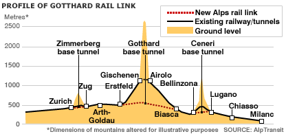 Whilst initially intended for freight, the service is expected to carry passenger trains; an underground railway station has been established one kilometer beneath the village of Sedrun, for use in the construction project, and there are plans to turn it into a passenger station, to be known as "Porta Alpina", or "gateway to the Alps":
Tourists will be able to arrive by train in the Alps in record time, and then be whisked up to fresh mountain air by way of the world's longest elevator.On one hand, travelling to the Alps by high-speed train, ascending in a lift and emerging in a tiny Alpine village does sound cool. On the other hand, I had the good fortune to travel from Zurich to Milan by the slow way—the train winding around the sides of silvery lakes, crossing bridges over valleys and corkscrewing its way up the Alps on the German-speaking part, going through a (relatively) short tunnel at St. Gotthard's Pass, and then coming back down on the Italian-speaking part, with its entirely different architecture and vegetation, and that was (as you can undoubtedly imagine) a magnificently scenic journey. A tunnel just wouldn't be the same.
2006/6/28
A London artist has produced a noise-level map of London, showing where the quiet places in this noisy city are.
(via Boing Boing) ¶ 0
2006/6/13
In Toronto, Canada, the local electric utilities have a tradition of disguising power substations as suburban houses, complete with balconies, windows and gardens. Known as "bungalow-style substations", the facilities have been built over many decades, in whatever style fit in best at the time, and according to a commenter, even hire someone to "live" in the houses on Halloween and hand out candy.
Meanwhile, in London, there is 23-24 Leinster Gardens, W2, where two terrace houses were demolished in 1867 to make what is now the District Line, and replaced with a convincing-looking and well kept-up façade.
When I lived at the end of Holden Street, North Fitzroy (map here), there was a house across the road which was condemned because it stood in the way of maintaining/replacing a water main that ran immediately beneath it. It had stood there for a year or two at least, slowly falling apart, no light emanating from its windows; at one point, a notice was attached to its front, detailing a plan to, after demolishing the house, build a façade across the front of the lot, in keeping with the neighbourhood's character. I don't know whether this has happened, or whether there is now a convincing pseudohouse in North Fitzroy; as of August 2004, the empty house was still standing, slowly, sadly falling apart.
(via Boing Boing) ¶ 1
2006/6/1
A German architect has a plan to solve housing shortages, generate wealth and absorb carbon dioxide by building new land from the sea using "mineral accretion":
A cargo ship drops anchor in choppy water 300 miles off the coast of North Africa. With practiced efficiency, its crew deploys the ship's crane and begins hauling house-size wire frames and reels of thick electrical cable from the hold. As quickly as this cargo appears topside, it is flung overboard, disappearing into the gray, swirling sea. When the decks are finally clear, the crew begins assembling floating solar panels that look like adult-size tinkertoys. The ship's engines rumble as the first of these ungainly structures is hoisted skyward and carefully deposited alongside. The activity continues until they form a vast spiral that dips below the horizon as the ship steams away. Five years later, a luxury cruise liner drops anchor at precisely the same place. Instead of finding bobbing rafts, the passengers lining its decks see the thriving island of Autopia Ampere.
Autopia Ampere will begin as a series of wire-mesh armatures anchored atop a sea mountain. Once in place, they will be connected to a supply of low-voltage direct current produced by solar panels. Over time, electrochemical reactions will draw minerals from the sea to the armatures, creating walls of calcium carbonate, which is what us landlubbers commonly call limestone.
One of the cornerstones of the new city's economy would be "limestone farming." ... Hilbertz envisions these products being lifted directly out of the sea into barges and ships, which could deliver them to seaports around the world. A limestone farm in the Caribbean could efficiently ship the building materials to coastal areas of North and South America, Europe and Africa, to inland North American ports on the St. Lawrence Seaway and Mississippi River systems, to most of Central Europe via the Rhine, Rhone and Danube rivers and to most of the Amazon basin in Brazil. A farm in the South Pacific could service the west coast of North and South America, and booming Pacific Rim countries.
The fact that ocean-grown cities could stand on their own economically and become independent and self-governing entities poses what Hilbertz believes to be one of the biggest barriers to their creation. He says there is no legal precedent regarding national ownership of a newly formed island that is beyond a nation's territorial waters.
(via Boing Boing) ¶ 0
2005/9/2
The residents of the Austrian village of Fucking are sick of English speakers finding treating their village as a joke (and stealing their road signs); however, the Daily Telegraph's writers obviously aren't:
"Let's just say there are plans in place to deal with this," the Kommandant warned darkly. "What they are, I am not at liberty to disclose, but we will not stand for the F---ing signs being removed. It may be very amusing for you British, but F---ing is simply F---ing to us. What is this big F---ing joke? It is puerile."
"The Germans all want to see the Mozart house in Salzburg. Italians and Russians always celebrate New Year here. Every American seems to care only about The Sound of Music (filmed around Salzburg in 1965). The occasional Japanese wants to see Hitler's birthplace in Braunau. But for the British, it's all about F---ing."
"Yet still there is this obsession with F---ing. Just this morning I had to tell an English lady who stopped by that there were no F---ing postcards."
His predecessor, Siegfried Hauppl, was equally dismissive when he was interrupted playing a game of Skat. "I am no longer the mayor so this F---ing problem is nothing to do with me," he growled, turning his back and studying his cards.
"The older people don't like being laughed at by some of the younger ones from other villages, but we are proud of our beautiful F---ing."It's all rather Benny Hill, isn't it?
2005/8/8
Tristan Da Cunha, in the southern Atlantic Ocean, the world's most remote inhabited island and one of the few remaining parts of the British Empire, now has a postcode. The island's Royal Mail postcode is TDCU 1ZZ. The governor has since received a parcel from amazon.co.uk, sent to commemorate the island's new postcode.
Curiously enough, while the island is served by Britain's domestic postal system, mail sent there is first sent to South Africa, a foreign country, where it is placed aboard a fishing boat, the total journey taking up to a month. (Tristan Da Cunha is not reachable by air, for lack of an airstrip.) Which means that either (a) it is one of very few British domestic destinations to which mail has to go through customs, or (b) this is a loophole which allows parcels to travel between Britain and South Africa without customs clearance.
2005/7/27
Some interesting observations on Australasian demographics, from the most recent KPMG Population Growth Report. The report confirms the "bloke drought" some Australian women have observed, and blames it on globalisation, with eligible bachelors decamping to more vital and/or exciting parts of the world. As one might expect, New Zealand is more affected by this than Australia:
"If you are a 34-year-old heterosexual woman in New Zealand, you have as much chance of finding a male partner of your own age as does an 85-year-old woman."
He believes this trend has contributed to New Zealand's "matriarchal society" - both its prime minister and governor-general are women.(New Zealand is a matriarchial society? Perhaps the Doug Anthony Allstars were onto something...)
Another part of the report highlights the "sea change movement", i.e., Australian aspirationals moving to small coastal towns:
Mr Salt believes the so-called sea change is now a legitimate "third Australian culture". "First it was the bush, then it was the 'burbs, and now it is the beach".Interesting how that list of "legitimate Australian cultures" omits the inner cities, without which Australia would have been little more than a nation of bourgeois curtain-twitchers eating Yorkshire puddings and mashed potatoes around the telly and tut-tutting disapprovingly along with the Herald-Sun. Could they have bought into the Howard-era silent-majoritarian doctrine that such rootless cosmopolitanism is somehow inherently un-Australian?
2004/11/12
A recent study at the John F. Kennedy School of Government claims to disprove the often cited anecdotal connection between poverty and terrorism. According to the report, a nation's poverty has little effect on the occurrence of terrorism in that nation; however, levels of political freedom strongly influence terrorism. Countries with high levels of freedom and strictly controlled autocracies are both less susceptible to terrorism than countries with intermediate levels of freedom (this can be seen in Iraq and Russia). Perhaps it has to do with the intermediate countries not having cultural institutions which evolved with their recently gained freedom, or having insufficient freedom to provide peaceful outlets for grievances whilst insufficient control to effectively clamp down on violent ones.
Another factor which increases a country's frequency of terrorism is apparently geography, with mountainous terrain, jungle and similar features offering safe havens to rogue groups, as well as sources of narcotics-related income. (via bOING bOING)
2004/5/5
The meetup.com database of venues is getting progressively more bizarre. One of the three choices for the Melbourne bOING bOING Meetup* was "Putters Adventure Golf, 10 Main Rd, Hobart". Compared to this, the network deathmatch centre in Lilydale or wherever that kept cropping up is almost sensible.
* Not that it matters; it's unlikely that there'll be a quorum for this one any time soon.
2004/3/31
There is a movement in Canada, a nation not known for its imperialist ambitions, to annex the Turks and Caicos islands. The islands are a British Crown Colony (i.e., essentially one of the few remaining parts of the British Empire; they are written up in Simon Winchester's Outposts as such), though, the site argues, closer ties with near-neighbour Canada, perhaps leading up to union, would have advantages for both sides (the Canucks would get a warm, sunny province and a foot in the door of the Caribbean/Latin American market (not to mention a forward base for their eventual invasion of the USA), while the islands would get a reduced cost of living, increased investment, expanded educational opportunities and subsidised health care. (via MeFi)
2004/3/3
2003/6/3
A Canadian company has devised a universal postcode system. With this system, a 10-character code, of the form "W2B00 8P2H0" uniquely denotes an area measuring approximately one square metre anywhere on the earth's surface. The Natural Area Coding System itself is quite simple; each character is a base-30 digit, and the two groups of characters refer to longitude and latitude as fractions of 360 and 180 degrees respectively.
This all sounds like one of those brilliantly original ideas, like Esperanto or Metric Time, which, for all their ingenuity, come up face-first against the brick wall of pragmatism and inertia, people being creatures of habit and all; except for two things: firstly, in the age of GPS, Natural Area Coding System codes will be easier to determine than traditional post codes, as there will be no maps or databases to look up, and also no questions of changing boundaries (as happens from time to time, for example when resident groups or landlords lobby to redraw the boundaries so their properties aren't in Footscray or South-Central LA or somewhere similarly insalubrious). And secondly, Microsoft are backing the idea, and plan to integrate it with their MapPoint map service. (Perhaps they hope that they can use it to lock customers into depending on Microsoft technologies or something? I wonder if it's patented.)
NACS could eventually become a world-wide postcode, replacing legacy postcode systems devised in the pre-GPS era. It would probably happen with shipping/courier firms utilising the codes internally, and businesses which deal with them putting them on their details, and finally postal services phase out the pre-GPS system and adopt this. Of course, if someone detonates an EMP bomb in the high stratosphere and fries all the GPS satellites (or if the Americans stop being our friends), we're all fucked; but if all the satellites disappear, we'd have more important things to worry about.
2003/1/22
A scholarly work by two Russian mathematicians positing a new chronology for British and European history, and seemingly proving that Britain didn't exist, and all references to it map to places in eastern Europe and the Balkans. "London" referred to either Constantinople or a Bulgarian town named Tyrnovo, England (or Albion) was Albania, Scotland was Scythia, the Welsh were Turks, and the Norman Conquest was actually a reference to fourth crusade and the conquest of Constantinople. The conspiracy of cartographers strikes again, so it seems.
(If this is true, and these things didn't happen in British history, then what did? Perhaps the Royal Family is actually descended from Odin (as their official genealogy is said to claim), or perhaps the Queen is a giant lizard?) (via Psychoceramics)
2002/4/19
Killer applications for the web: A map of library cats residing in libraries and bookshops around the world. Well, so far, mostly in North America and Australia. Hmmm... wasn't there at one stage a cat in residence at PolyEster Books?
2002/3/6
A catalogue of "big" landmarks in Australia, or a homage to the Australian tradition of making cyclopean replicas of random objects and putting them in various country towns to attract tourists or the easily amused.
2001/1/21
Speaking of historical railway maps, here is an archive of maps of the Victorian Railways network, by decade. Fascinating; now I know that the Fitzroy line closed sometime in the 1980s, and the branch line to East Kew (which once linked Oakleigh to Fairfield or somesuch, around 100 years ago; not to be confused with the Kew one) was closed in the 1950s sometime. Though there is no trace of the rumoured railway line which ran from Elsternwick to Oakleigh or somewhere like that.
(I have been interested in historical maps for some time; since I started looking through a 1970s-vintage Melway street directory which had belonged to my late stepfather, probably from back when he was a features editor at the Herald. Unfortunately, this book has since been lost, some time before when I became curious about the dismantled railway lines of Melbourne.)